Summer Sports
Agonikak National Recreation Trail
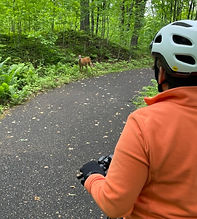
The Agonikak National Recreation Trail starts at the Michigan DOT roadside park just north of Land O’ Lakes on highway 45 and extends 12 miles north to Watersmeet. This is a great trail for hiking, biking (35mm or wider tires recommended) and snowshoeing in winter. The Agonikak Trail is a component of the 38-mile Wilderness Lakes Trails bike and pedestrian system that traverses 2 states and encircles the Sylvania Recreation Area.
Land O’ Lakes Bike Trail
This trail is approximately 12 miles each way, headed west along highway B from Land O’ Lakes. The first few miles are in a bike lane on highway B before being on its own paved path for most of the remainder of the ride. The Forest Lake Cafe and Wine Store is about 8 miles from town and to go all the way to Thousand Island Lake Road is another 4 miles. This is also part of the Wilderness Lakes Trail.
Sylvania Wilderness Area Biking, Hiking, Camping, Canoeing, Kayaking
We are fortunate to have the Sylvania Wilderness and Recreation Area so close to us. This area offers many activities to the outdoor enthusiasts. As mentioned above, the Wilderness Lakes Bicycle Trail circles the Sylvania Wilderness area. Hikers, campers, canoers and kayayers will find ample opportunity to enjoy the wilderness activities shown on this map. The Ottawa National Forest Visitor Center in Watersmeet is a great source of information for first time visitors to the wilderness area. Whether in a canoe or kayak, avid paddlers may enjoy doing the seven lake loop in the wilderness, putting in on Crooked Lake and portaging/paddling through Mountain, East Bear, West Bear, Kerr and High Lake before portaging back to Crooked to finish the loop. The Sylvania Wilderness and Recreation Area map shows where you would put in and/or portage for any paddling sports in the Sylvania Wilderness.
Wisconsin River Kayaking, Canoeing
Lac Vieux Desert is the headwaters of the Wisconsin River. Paddlers can put-in kayaks or canoes at the launch next to the small bridge on Highway 45 over the Wisconsin River just south of Land O' Lakes and can paddle north toward the headwaters or south and then take-out at Rummels Road between Conover and Land O' Lakes or at the bridge at Highway K in Conover.
Conover – Phelps Bike Trail
The Conover – Phelps bike trail is an 11-mile trail that connects the commercial centers of the towns of Conover and Phelps. There is a considerable slope on 1.9 miles at the east end near Phelps and that is paved. The remaining 8.7 miles is mostly flat repurposes railroad bed that consists of compacted granite aggregate.
Heart of Vilas County Bike Trail System
The Heart of Vilas County Bike Trail System is one of the premier bike trails in Wisconsin. This mostly paved 52 mile trail network connects the communities of Saint Germain, Sayner, Boulder Junction, Manitowish Waters and Mercer. It includes flat to rolling terrain. There are 20 parking areas along the way to enable you to break up the ride into distances you prefer. There are restrooms and scenic picnic areas along the trail. Heart of Vilas County Bike Trail map.
Bond Falls State Park
A first time visit with friends and family is not complete without a trip to Bond Falls, located about 20 miles north of Moon Lake
Gateway Golf
Play the 9 hole golf course right on the grounds of the historic Gateway Lodge.
Northern Waters Casino Resort Golf
The Northern Waters Casino in Watersmeet has an 18 hole golf course that presents a good challenge for many golfers.
Outdoor Recreation Parks for Summer Activities
Minocqua Winter Park
(yes, for summer activities too)
Enjoy disc golf, hiking and trail running at Minocqua Winter Park. A beautiful, year-round outdoor recreation destination located in Wisconsin’s great Northwoods.
WinMan Trails
Enjoy hiking, trail running, mountain biking and one wheel riding on the trails at WinMan. WinMan is located between Winchester and Manitowish Waters.
Winter Sports
Snowmobiling
Downhill Skiing
Cross Country Skiing
Within just over 10 miles from Moon Lake are 4 trail systems that allow for outdoor winter silent sport recreation. In addition to the information below you can find information for ski conditions on the website “skinnyski.com” From the main page select “Trails” and on the new page select “Ski Trails”. You can use the map or search a ski trail name to get information. Thank you to Bob Turnquist for the good trail descriptions below.
Land O Lakes Fish and Game Ski Trail
13 kilometers (7.5 miles)
Allowed: Classic Skiing and Snowshoeing
Fee: Donation
The parking lot for the trail is on the East Duck Lake Road, 0.6 miles north of the intersection of the North Moon Lake Road with the East Duck Lake Road. The Land O’ Lakes Fish and Game ski trail is entirely within the Ottawa National Forest. There are trails on the east side and the west side of the parking lot. The East Trails travel through a forest dominated by evergreens with terrain that is gentle and rolling and suitable for skiers of all abilities and is better suited for snowshoeing. The West Trails travel through a forest of primarily hardwoods and offer more hills and winding runs through the natural hilly terrain. Novice skiers may have difficulty on a few of the West Side runs and there are areas where the trail is not really wide enough for snowshoeing.
There are no bathrooms or other facilities.
Sylvania Outfitters
25 kilometers (15 miles) Phone 906-358-4766
Allowed: Classic Skiing and Snowshoeing
Fee: $10 for skiers
Rentals: Snowshoes and Ski Equipment are available for rent and may be taken to other trails.
Sylvania Outfitters trails are in the Ottawa National Forest. The forest is primarily hardwoods and the terrain is hilly. Some of the trail is rather narrow and some of the turns are rather tight, especially as you ski further south on the trail. The first few kilometers of trail are well suited to all levels of skiers. Most of the snowshoeing is on the northern sections of the trail just south of the trailhead. There is a warming area in the Sylvania Outfitters building and outdoor bathrooms.
Sylvania Outfitters Ski Trail Map
Pioneer Creek Cross Country Ski Trail
13 kilometers (7.5) miles)
Allowed: Classic Skiing, Freestyle Skiing, Snowshoeing, and Fat Biking
Fee: Donation
Rentals: snowshoes
The Pioneer Creek Trail is located at the Conover Town Park, ½ mile east of Highway 45 on Highway K. This is a wide trail with a skating and snowshoe lane the entire length of the trail. Near the beginning of the trail is a fairly large hill requiring caution for novice and intermediate skiers. Since the trail is wide, there is plenty of room to snowplow to keep your speed down. The rest of the trail does have hills, but none too demanding. There are heated bathrooms and changing rooms at the trailhead.
Pioneer Creek Ski Trail Map
Afterglow Lake Resort
18 kilometers (11 miles) of XC trails. 8 miles of snowshoe trails.
5 Miles Groomed Single Track Fat Bike Trails. Ski Trail connects to the Phelps Ski Trail
which is for classic skiing only.
Allowed: Classic Skiing, Freestyle Skiing, Snowshoeing, and Fat Biking
Fee: $10 for skiing, $5 for snowshoeing
Rentals: Snowshoes
Afterglow Lake Resort features wide, well groomed trails for skiing only. Separate trails for snowshoeing and Fat Biking. There are trails for skiers of all levels and there are specific expert runs.
There are bathrooms and a very large warming room with fireplace and couches and easy chairs. The room has a great view of Afterglow Lake.
Afterglow Cross Country Ski Map
Conover Area Ski Trails
https://www.conover.org/trails/cross-country-skiing-trails/
Three Eagle Trail
4.9 miles of XC trails groomed for skate and classical skiing. The Three Eagle Trail is part of a longer 12.7 mile bike trail in summer, that connects Eagle River and Three Lakes.
Three Eagle Cross Country Ski (and Bicycle) Map
Outdoor Recreation Parks for Winter Activities
The Glide at Winter Park in Boulder Junction
The Glide offers a unique opportunity to skate on a traditional rink or on a .83 mile ice ribbon that winds through the woods on a groomed trail of ice.
The Snowflake Ice Rink in Land O’ Lakes
The Snowflake Ice Rink located behind the town hall provides ice skating for the public at no charge while listening to music, warming house to take the chill off, restrooms, along with plenty of skates in all sizes for your use. No hockey is allowed in the buidling. Skates are available to use.
Minocqua Winter Park in Minocqua
The Minocqua Winter Park offers cross country skiing, tubing, skijoring, snow shoeing, and skating.
WinMan Trails in Winchester
WinMan Trails offers snow shoeing, cross country skiing and fat tire biking.
If you have suggestions for other content that you would like to see added to this page, please send an email to webmaster@moonlake.org.